Another Day, Another Alpine Pass.




I am not sure when it happened but at some point Bent went to retrieve his Ursak and he slipped on a log and tweaked his knee. There was a fair amount of cussing and self admonishing as Bent limped around rubbing his knee. Bent did attempt to stretch out the knee and was hoping he would be just able to “walk it off”. The initial part of the hike was predominantly downhill and the knee would do just fine but going up North Kananaskis Pass did not make the knee very happy nor Bent.


We headed out just after 8 am. Not a particularly early start but given the events of last night a perfectly acceptable start time. We only had around 14 km to hike so we were not pressed for time.
Immediately after leaving Bent and Spencer stopped to fill up with water. I took the opportunity to take some photos of Palliser Lake. Bent also took the opportunity to change into his rain pants. Neither Spencer nor I chose to hike in rain pants and would suffer because of our choice.


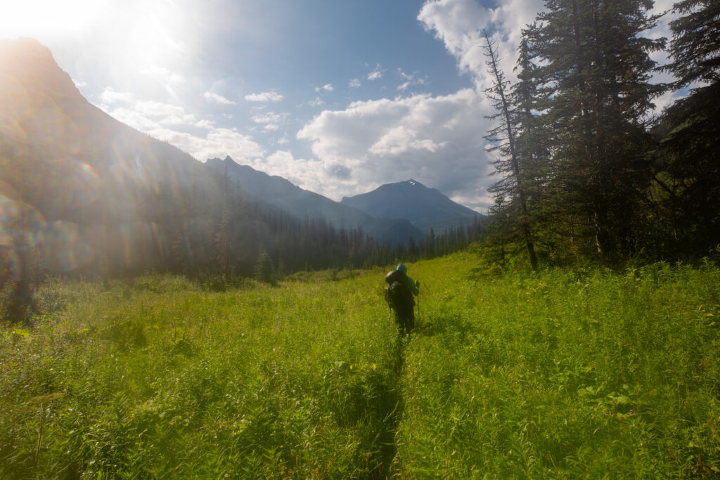
Going down the trail right away the benefit of wearing rain pants became apparent. The trail was quite overgrown in places resulting in repeatedly brushing up against the wet plants overhanging the trail which quickly soaked our pants.


The wildcamp had been my goal yesterday but I was hesitant to push down the trail since there is limited room for camping. Once we found our spot at Palliser Lake I was content to just stay there. This campsite would of had better drainage.


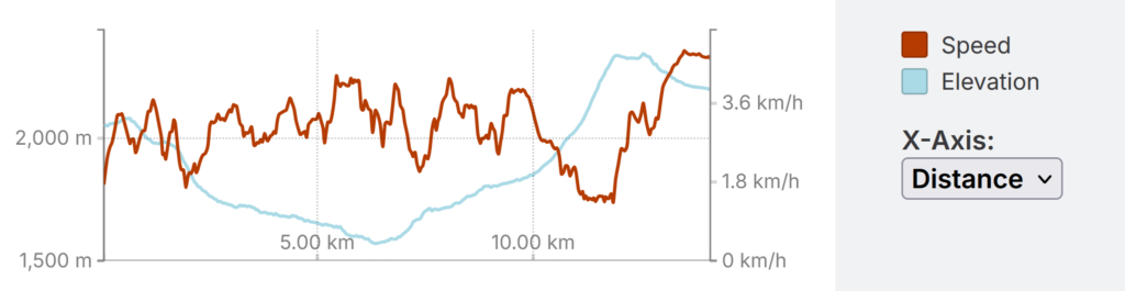
The trail follows the outlet of the pond, which is really just the continuation of the creek draining Palliser lake, along a short flat section before the trail heads downhill in earnest dropping 200m in just 1 km.


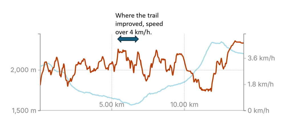
One of the challenges in making our way through the brush was that we could not see where we were putting our feet. Our pace was slower than on clear trail because even though I knew there was good trail underfoot there was the occasional rock or log that lay on the path that could create a tripping hazard had me being somewhat cautious as we made our way down the trail. At one point on the trail there was a massive tree down across the trail. We made our way around by carefully bushwacking for a few minutes this did not help our speed on the trail.


As we closed in on the bottom of the descent we came across a section of trail that had obviously had received some trail maintenance. The trail suddenly opened up with a clear hiking path and the brush cut back at least two feet on each side. The reworked trail continued to the the bottom of the climb and up to the junction to cross over LeRoy Creek. When I looked it up later online The Great Divide Trail Association had a trail crew in the area early in the summer. As I type this the Great Divide Trail Association has a trail maintenance trip planned for July of 2026 to continue clearing the trail northbound towards Palliser Pass.


Once we crossed the Palliser River we initially followed the north bank of the LeFroy Creek up the lower slopes of North Kananaskis Pass. The river crossing was just 45 minutes since we had left the wildcamp. We had hiked a total of 6 km in 2 1/2 hour. The majority of the rest of the day would be the climb up North Kananaskis Pass.


I had obviously not been checking my phone because the app would have had us crossing about 0.6 km earlier.


About 800 m after the water crossing the trail hangs a hard right and stops following the creek and heads up with a vengeance. We would climb 460 m in just 1.6 km arrive at North Kananaskis Pass. With a elevation gain of approximately 275 m/km over the last 1.6 km makes this probably the steepest section of trail I have hiked in the Canadian Rockies. A quick peek at the some profiles shows that North Kananaskis Pass is steeper than the hike up over the Floe Lake Headwall or the steepest section of Owen Creek and similar to the last 1.7 km of the Tanner Trail in the Grand Canyon which is quite the grind at the end of a long day.
I went hard up North Kananaskis Pass for two reasons. First I simply just wanted to test myself physically. I had a rough first couple of days on trail and I wanted to see if I had fully recovered. Second there were some iffy clouds around and I was trying to get up and over the pass before there was any lightning. I had a bad experience with lightening in the past and I am still a little nervous when exposed at elevation in poor weather. It would take me 1 hour 3 minutes to hike that 1.6 km to the pass and I arrived under blue skies.


As I approached the final section the trail kicked even more and my speed dropped to a little over 1 km/h.


I am not personally happy about it but the naming of mountains and other features in the north end of Peter Lougheed Provincial Park is dominated by military figures and battle ships. The name Beatty though has a number of features including a mountain, glacier and a lake so I did look up and include the background naming history. Admiral David Beatty served in the Royal Navy during World War I. He commanded the British strike force at the Battle of Jutland in 1916 and later became Commander in Chief of the Grand Fleet from 1919–1927.
We arrived at Turbine Canyon Campground at 1:55 pm. I quickly chose the spot that Laura and had in 2024 on our annual backpacking trip. I liked the spot because it was somewhat sheltered by the trees.


After some reflection Spencer decided to make a break for the trailhead so that he could go home a day early and see his kids. It was only a 15 km or so mostly downhill hike on good trail back to the Upper Interlakes Trailhead and a quick text home via the Rogers Satellite service confirmed the availability of a pick up and Spencer was soon off down the trail.
Bent and I had some options of places to visit in the area. Bent still nursing his sore knee declined the idea of a 6 km return hike up to the Haig Glacier. Instead we toured the local area which includes the campground’s namesake canyon and chilled for the afternoon. Bent also came to the conclusion that his knee was not getting any better and that he felt the need to skip our planned hike up and over Northover Pass and exit the trail tomorrow following in Spencer’s footsteps to the Interlakes TH. A quick text to Ken on my SPOT device confirmed a noon pick up.


It was an eventful day on trail and the lesson from today is you always have to be flexible with your plans. Sometimes events transpire that require modifications to the plan. It is a simple fact the trail will still be waiting next year.